Posted by Weatherflow ● September, 2023
The Perfect Storm: How Tornadoes Form

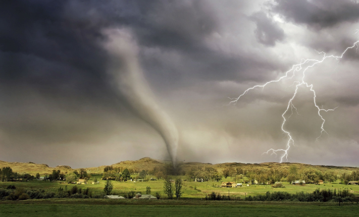
Easily creating wind speeds of up to 200+ mph, tornadoes are a well-known terrifying yet mesmerizing force of nature. You've probably seen these monstrous, swirling giants tearing through the landscape in movies or on the news, but have you ever wondered how they form? Well, hold onto your hats (literally) because we're about to break it down for you.
THE CLASH OF THE TITANS
Tornadoes don't just pop out of thin air; they result from a meteorological showdown. Imagine warm, moist air from the Gulf of Mexico colliding with cold, dry air from the north. This collision is like the ultimate weather showdown, and it's the first ingredient in our tornado recipe. You may have heard of the infamous Tornado Alley, known for producing conditions well-suited for tornado formation.
THE SUPERCELL DRAMA
Enter the supercell, a rotating thunderstorm that's like the superstar of tornado formation. Within the supercell a horizontal spinning tube, known as a mesocyclone, starts to form. Think of it like a cosmic kitchen mixer, but on a massive scale.
THE UPDRAFT ELEVATOR
Now, let's talk updrafts. These invisible elevators within the supercell lift warm, moist air upward. As this air rises, it starts spinning horizontally, thanks to the mesocyclone's influence. It's like a weather blender in action.
ENTER THE TORNADO
Here's the magic moment: when the spinning warm air gets a vertical push, a tornado is born. The air twists upward, forming a funnel that extends from the thunderstorm cloud down to the ground. It's like a tornado's grand entrance, and it's as spectacular as it sounds.
TORNADOES OF ALL SIZES
Remember, not all supercells spawn tornadoes, and tornadoes come in all shapes and sizes. From tiny, weak twisters to massive, destructive monsters, nature's got a tornado for every occasion.
- The Tri-State Tornado (1925): This tornado holds the record for the longest path length in recorded history. On March 18, 1925, it tore through parts of Missouri, Illinois, and Indiana, traveling a staggering distance of approximately 219 miles (352 kilometers). It also ranks as one of the deadliest tornadoes in U.S. history, with a death toll of at least 695 people.
- The Hallam, Nebraska Tornado (2004): This tornado holds the record for the widest tornado on record. It struck Hallam, Nebraska, on May 22, 2004, with a width of nearly 2.5 miles (4 kilometers). Fortunately, it caused relatively minor injuries and no fatalities due to the sparse population of the area.
- The El Reno Tornado (2013): On May 31, 2013, a massive EF5 tornado struck near El Reno, Oklahoma. While it had a path length of approximately 16.2 miles (26 kilometers), it had a width of nearly 2.6 miles (4.2 kilometers) at its peak. Tragically, this tornado claimed the lives of several storm chasers, including well-known meteorologist Tim Samaras.
These tornadoes serve as stark reminders of the destructive power of nature and the importance of preparedness and safety measures in tornado-prone regions.
So, in a nutshell, tornadoes form when warm, moist air collides with cold, dry air, creating a supercell thunderstorm. Within that supercell, a spinning mesocyclone forms, and when a rising updraft turns vertical, you get a tornado. It's like Mother Nature's wild rollercoaster ride.
Remember, tornadoes are no joke. They can be extremely dangerous, so if you ever find yourself in their path, seek shelter and stay safe. But for now, you've got the inside scoop on how these twisting terrors come to be. Stay curious, weather enthusiasts, and keep an eye on the skies!
TORNADO SAFETY: WATCH VERUS WARNING
A tornado watch and a tornado warning are two distinct alerts issued by meteorological agencies to inform the public about the potential for tornadoes, but they have different meanings and implications:
- TORNADO WATCH: A tornado watch is a statement issued by meteorological agencies (like the National Weather Service in the United States) when conditions are conducive to the development of tornadoes. It means that tornadoes are possible in the designated watch area. A tornado watch is a precautionary measure to alert people that they should be prepared for the possibility of tornadoes. It provides advance notice, often several hours, to allow residents to be on alert, stay informed, and make plans in case a tornado actually forms. During a tornado watch, you should stay informed about the weather conditions, listen to weather updates and warnings, and have a plan in place for seeking shelter if a tornado warning is subsequently issued.
- TORNADO WARNING: A tornado warning is a more urgent and specific alert issued when a tornado has been observed or indicated by weather radar. It means that a tornado is imminent or already occurring in the warned area. A tornado warning is a critical warning that demands immediate action. When a warning is issued, it's time to take shelter immediately and seek safety. It is a call to action to protect lives and property. When a tornado warning is issued, you should take cover immediately in a safe location, such as a basement, storm cellar, or an interior room on the lowest floor of a sturdy building. Do not wait; take shelter as soon as you hear or receive the warning.
In summary, a tornado watch is a cautionary alert indicating the potential for tornadoes in an area, while a tornado warning is a specific and urgent alert indicating that a tornado is either occurring or imminent. Knowing the difference between the two and understanding the appropriate actions to take can be crucial for staying safe during severe weather events.
TORNADO IN A JAR EDUCATIONAL ACTIVITY
This blog is also a part of our Weather Safety and Science Kit activity resources. If you've got a weather-inspired kid ages 5-10, head over to our Weather Safety and Science Kit Activities to check out the Tornado In A Jar activity, plus more fun weather focused learning resources and activities!
Back to: Articles, Extreme Weather

